


|
Dick's Adventures of 2025 - Part 1 |
|
| Photos Related Links More Travel Reports | |
| Adventures
of 2016 Adventures
of 2017 Adventures
of 2018 Adventures
of 2019 Adventures
of 2020
Adventures of 2021 Adventures of 2022 Adventures of 2023 Adventures of 2024 Adventures of 2025 p2 |
|
| Kings
Canyon Grant Grove
Visitors from the East - San Joaquin
Gorge, Yosemite
Edison Point Make-up Finegold Fisherman's Trail Finegold North |
|
| Kings
Canyon National Park - Grant Grove etc. We didn't exactly have cabin fever, but we were definitely ready to get out into the hills and mountains of Central California. So on January 12 daughter Teri and I headed east on State Route 180, into Kings Canyon National Park. Her son Johnny and wife Brittany had gone there a few days earlier, her first visit despite living in Fresno all her life. Their trip partly inspired ours. We picked up sandwiches at a Subway on our way out of town, and drove into the park and to the Grant Grove parking area. We had checked the weather and were dressed for the 38 degree temperatures, fairly comfortable as long as there was no wind. Despite the season and the temperature there were dozens of people enjoying the bright, clear winter day. Although there are longer loop trails around the grove, we just basically walked up to and around the General Grant Tree, designated in 1926 as the Nation's Christmas Tree. Although a relatively young 1,650 year old, it's the world's second largest Sequoia, after the General Sherman in adjacent Sequoia National Park. There are probably a couple dozen other impressive sequoias visible along the route. |
|
 |
 |
| The top of the General Grant | A full view of the tree |
|
Our next stop was the gift shop at Grant Grove Village, with a specific task in mind. When the Ramblers hiked to the General Sherman Tree in August 2023, my great grandsons Colton and Jack accompanied us. Jack acquired a tiny Sequoia seedling, which prospered for a while at his family cabin near Shaver Lake. However, either the summer heat or other unknown factors killed the tree late in 2024. His parents had hoped to get him a new one when they visited, but the gift shop was closed. Teri and I took it on ourselves to buy a replacement. We
ate our lunch at a picnic table on the plaza behind the gift shop,
then decided to drive a short distance south on the Generals
Highway, to the Kings
Canyon Overlook |
|
 |
 |
| Snowy Sierra peaks from the Kings Canyon Overlook | Mt. Goddard is the highest peak in this view |
|
After enjoying the view for a while, we started back down the mountain, arriving back home where it was above 60 degrees. Normally this would seem cool to me, but after braving the 40 degree high in the mountains, it was positively balmy. --Dick Estel, October 2019 |
|
|
Visitors from the East - San Joaquin Gorge,
Yosemite (Photos by Linda Estel and Dick Estel) In early April my sister Linda and her wife Anne flew out from Duluth to Portland, where Anne has a sister and a niece. After visiting there for a few days they rented a car and took a leisurely drive down to Fresno, stopping twice overnight. Daughter Teri has a large mobile home and had invited Linda and Anne to stay at her house, so in the afternoon of April 4 I went there to help greet them. Teri fixed us a yummy dinner, and I also stayed there overnight, with the rest of the family coming to join us the next day - Teri's sons Johnny and Mikie, daughter-in-law Brittany and grandsons Colton and Jack, Mikie's fiancée Haley, my daughter Jennifer from Oakhurst and my daughters' mom, Jackie. We had a good dinner and a nice visit, learning a great deal about the weather and other conditions in northern Minnesota, and the labor-intensive practice of making homemade maple syrup. Linda and Anne have won prizes with their syrup at the Minnesota State Fair. Our visitors had previously advised me that it is cold and bleak in their area right now, and that they would enjoy a hike in the foothills to see wildflowers, so on Sunday Teri, Linda, Anne and I, joined by Teri's friend Maria, drove to the San Joaquin Gorge and hiked a short distance on what we call the upper trail, but is officially the San Joaquin River Trail. You can follow this route high above the river for 14 miles to Sky Harbor on Millerton Lake, but none of us have ever hiked that distance, nor will we. We were rewarded for our efforts by many species of wildflowers, as well as acres of green grass, and the blue oak trees leafing out. |
|

|

|
| Dove lupine | Blue dick |
|
|

|
| Invasive thistles and a lichen-covered rock | Overcoming adversity |
|
On past hikes (when I was young and in my 70s) I always tried to go a little farther each time I walked this trail. This time I went a lot less distance than ever before. I'd love to blame my hiking companions, but when they wanted to turn back, I was also ready. We had gone the distance that is always my goal - half of far enough. As we often do after hiking at the Gorge, we stopped a few miles down the road in the village of Prather, where Auberry Road joins State Highway 168. This is the location of Velasco's, an excellent Mexican restaurant, where everyone enjoyed a delicious and well-earned lunch. The next day, Monday April 7, was the centerpiece of Linda and Anne's visit to central California. When they first announced their plans to visit the west coast, they offered to treat me to a night at the Ahwahnee Hotel in Yosemite Valley. This iconic upscale facility was opened in 1927, and has undergone upgrades and repairs, including some extensive work in the last couple of years. When I attended Mariposa County High School, 40 miles from Yosemite Valley, we had our proms at the Ahwahnee, so I had eaten there but never stayed overnight. Linda skipped the proms but has had a long-time desire to spend a night there. More about this later. |
|

|

|
| The iconic Ahwahnee Hotel | Yosemite Falls and the hotel |
|
Linda and Anne picked me up around 10 a.m. and we drove up State Highway 41, through the town of Oakhurst at 2,000 feet and the village of Fish Camp at 5,000. On a meadow beside the road here we saw a large patch of snow, and after that there were small amounts of snow along the road the rest of the way to the highest point, Chinquapin at 6,000 feet, where the road to Glacier Point leaves the main route. Here there was quite a bit of snow on the hills above us. From this point the road descends 2,000 feet to the floor of Yosemite Valley. Near the bottom it passes through the 4,233 foot long Wawona Tunnel, and as you emerge you are greeted by the iconic view of the valley, with El Capitan on the left, Bridalveil Falls on the right, and Half Dome and Cloud's Rest beyond the upper end of the valley. This view is similar to that seen by the Mariposa Battalion, believed to be the first white men to see the valley, although they entered the area at a point a few hundred feet higher in elevation. |
|

|

|
| Tunnel View - El Capitan, Half Dome, Bridalveil Falls | Cloud's Rest at 9,926 feet is buried in snow |
|
After enjoying the view here for a while, we drove down to the Bridalveil Falls parking lot. A short trail leads up toward the base of the falls, where heavy mist can leave visitors soaked when the falls is at its peak. Recently a new viewing area was constructed, accessed by a bridge across Bridalveil Creek. Although the falls looked big, it was not peak season, and a small amount of mist proved to be "just right." When there is a breeze, which is almost always, the falls drifts from side to side, adding the the spectacular scene. |
|

|

|
| Bridalveil Falls | Dick, Anne and Linda at Bridalveil |
|
We made a few short stops on our way to the hotel, mainly to look at the park's highest waterfall, Upper Yosemite. Even with a good flow, the breeze here also moved the fall from side to side. |
|

|

|
| Upper Yosemite Falls drifts in the wind | Lost Arrow stands out from the cliff a short distance east of the falls |
|
We finally arrived at the entrance to the hotel, where we were met by a friendly and efficient valet parking staffer. It was about 15 minutes before check-in time, but she called the front desk, and said that one room was ready, and we could take all our luggage there. For just one night we had only one bag each, and managed to carry them in ourselves, taking the elevator to the 2nd floor. The rooms are nice, but nothing spectacular. Mine had two double beds and a small sofa. The supersize room rates are for the view. We had a view of Yosemite Falls from both rooms. Rooms on another side of the building look out at Half Dome. Rooms with less spectacular views cost less (but are certainly not cheap). |
|

|

|
| The view from our rooms at the Ahwahnee | Seasonal falls cascades down the Royal Arches |
|
When Linda first emailed me about this outing, I replied that I would buy drinks at the bar, so once we settled in we went downstairs to that facility. Anne had wine, Linda had gin and tonic, and I had a cinnamon maple bourbon sour. Whiskey sours were our drink of choice early in my marriage, but I have moved on to just bourbon and soda. My experimental choice was OK, but next time I would ask them to leave out the maple syrup. We had not finished our drinks when we received notice that our table for dinner was ready, so we packed up and went to the grand dining room. Due to remodeling, the kitchen is not fully operational and there is no menu. However, the prime rib, tri-tip, chicken and other offerings on the buffet were more than satisfactory. We would also enjoy the breakfast buffet the next morning. Service was impeccable - empty plates were removed within a minute, and replacement silverware and napkins provided as needed without us asking. There was a big moon that night, and I could look out and see the falls most of the night. I could not see the movement of the water, but I could see the white shape of the falls. On Tuesday morning, after breakfast, we went out for a walk. We followed a path that led to cabins that are part of the hotel complex scattered among the trees, then cut across to an official hiking trail. The hotel is located close to the northern side of the valley, just down from a formation in the cliffs called Royal Arches. These are not technically arches, which implies an opening in the rock, but instead an area where rock has broken off through exfoliation, leaving a series of overhanging curves. A stream, known as Royal Arches Cascades, runs down the cliff face. Once on the trail, we found ourselves at a place where this creek covers the way, and the trail is officially closed. Water runs down in other locations also, as seen in the photo on the right above. The dramatic North Dome is seen above the arches and the waterfall. |
|

|

|
| Royal Arches Cascade | North Dome towers above the arches |
|
It was approaching the 11 a.m. check-out time, so we walked back to the hotel, packed up, called for the car, and turned in our keys (REAL keys, not cards). We went out to the main road and drove around the area that used to be called Government Center (maybe it still is). This is the location of a visitor center, museum, grocery store, post office, and employee residences. There was no parking available and nothing we really wanted to see here, so we drove on to where there was a nice view of Lower Yosemite Falls. Linda dropped Anne and I off and went to find a parking place, which took her less than two minutes. She soon joined us and we enjoyed views of the falls, including one spot where we could photograph both Upper and Lower Yosemite. We also stopped where we had a striking view of the front of El Capitan, the world's largest granite monolith. A sign where we parked said "follow the fence line to the view point." Since we could see El Capitan very well from where we were, I followed to see what view they were referring to, and saw that I was looking at the Cathedral Spires, two fingers of rock that stand out from the cliffs on the south side of the valley. In addition to rocks and water, we saw two coyotes. The first was in Wawona, walking briskly along the side of the road, as if he was going from the campground to the store to pick up some fresh rabbit. The second came out of a meadow and walked on the road behind us near where we had stopped to look at Upper Yosemite. Linda managed to capture a photo of him. |
|

|

|
| Lower Yosemite Falls |
Between upper and lower, the creek drops an additional 700 feet in a series of cascades |

|

|
| El Capitan, living up to its name | The Cathedral Spires |
|
In this short visit, we had managed to see many of the valley's major points of interest, including Ribbon Falls, the face of Glacier Point, the Merced River, several ephemeral seasonal falls (including Horsetail, which creates the rare "firefall," and Silver Strand, visible from Tunnel View), and various meadows. As we drove homeward through the tunnel, we made a final stop a quarter mile past it where we had a final view of Half Dome and El Capitan. Bridalveil is hidden from this vista point, but we could look across the Merced River Canyon at Cascade Falls (AKA The Cascades), which tumbles down the north side of the canyon west of the valley, culminating in a 500 foot vertical drop. From this place, we continued our 94 mile journey back to my house. Later that evening I joined them at Teri's place, where we enjoyed a tasty chicken dinner. The next day Linda and Anne were driving to Hollister, which would be their base for a visit to Pinnacles National Park, where they hoped to see condors. They did not see any of these huge, elusive birds, but they saw squirrels, a wild turkey, a rattlesnake, and later, otters in the ocean. Their next stop was at Asilomar near Monterey, a night at Half Moon Bay and finally a flight from the San Francisco Airport back to Duluth, where they were delighted to find warm weather and most of the snow melted. --Dick Estel, April 2025 |
|
|
Edison Point Make-up
When the Ramblers went to Edison Point on March 26, I was not able to hike yet, but I went along for the ride, and sat at the trailhead reading, and walked around that level spot for a minute or two. With the weather warming up on April 24, I wanted to get in at least one more hike in the foothills, so I packed a lunch and set off for Pine Flat Reservoir, and walked the first half mile of this loop trail to the point. This part of the trail is fairly easy, with some gentle up and down. I've walked the entire loop, which is challenging for all but the most physically fit hikers, and I had no desire to repeat it. |
|

|

|
| An old hiker on the Edison Point Trail | Where the trail approaches the point |
|
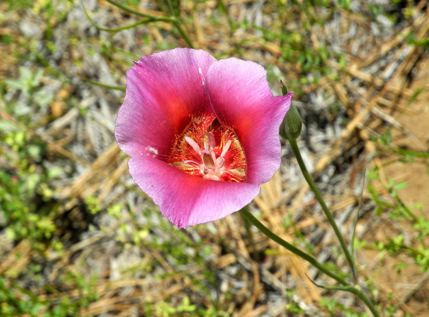
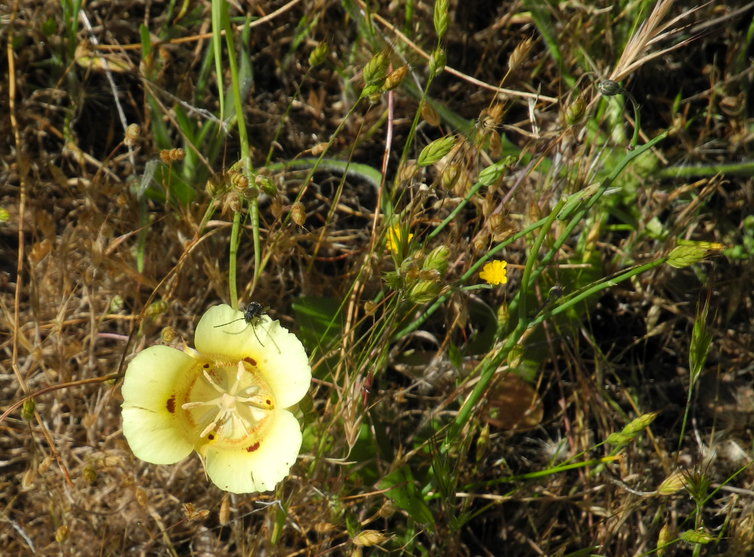
Many of the early flowers had gone to seed or wilted away entirely, but there were still quite a few late-blooming species around. Probably the most numerous were Mariposa Lilies, one of the foothills' most beautiful blossoms. They do not grow in mass carpets of color, but there were still more than I had ever seen before at this location. There are purple and yellow variations, but the ones I saw were all the more common white. Another flower along the trail looks from a distance like a dandelion puff ball, but on close examination can be seen as a round cluster of blossoms, each with about ten long, slender white petals. I have not been able to identify these, and they too were out in the greatest numbers I've ever seen anywhere. There were flowers along the road that I did not see on the trail. The most common was common madea, thick along Trimmer where the road goes past the Oak Knoll store. The flashy blazing star were in bloom along the road by the lake. There were plenty of these plants along the trail, but none were in bloom. |
|

|

|
| The glorious Mariposa lily | These remarkable flowers need a name |

|

|
| Purple brodiaea and common madea | Another unidentified flower |
|
The part of the trail I walked goes out the side of the hills to an electrical transmission tower, which is part of (what else?) the Edison Hydro Project. This section of the trail is actually a rough dirt road that provides access to the tower. It extends along the power line on the other side of Trimmer Springs Road, and I've walked part of that route in the past, but it is very steep. When I finished my hike, I drove up the road about a mile to a place where there is a big flat spot, set up my chair and enjoyed lunch with a view of the lake. Storage was at 76% of capacity, up from the 65% seen by the Ramblers a month earlier. The grass is still green, but drying out fast. Flowers that were out in small numbers included lupines, poppies, milkweed, and a couple of unknowns. The old saying about travel, that half the fun is getting there, was certainly true on this date. There's not much fun while the road is still in the flat valley, but as soon as it enters the hills and runs parallel to the Kings River, there's plenty to see. The wildflowers that line this part of the road are all busy making seeds for next season, but a man-made object caught my eye. Between where the road turns north away from the river and where it starts up the hills to get above the dam, there has been an ancient shed that has looked for decades like it could fall down at any moment. Some time during the past year it did indeed collapse. I stopped and took photos in January of 2017, so of course I had to park and take a series of "after" photos on this trip. |
|

|

|
| In 2017 this ancient shed looked like it was ready to collapse | But it lasted until 2024 |
|
My hike was just over a mile total, a distance that is within my goal of hiking one to two miles. The weather was warming up, but a cool down was forecast, so I am already planning one final hike in April before hot weather kicks in. --Dick Estel, April 2025 |
|
|
Finegold Fisherman's Trail
I hiked on this trail a year ago for the first time, and with the weather staying fairly cool, I wanted to make at least one more excursion into the foothills. The starting point is the Finegold boat launch and picnic area on Millerton Lake, just past Sky Harbor. It's an unofficial trail used by cattle and fishermen that goes upstream along the Fresno County side of the lake from the parking area. Last year I struggled to assign one of my unofficial names to it, settling on the unsatisfactory "Secret Trail." A year older and hopefully wiser, I decided on Finegold Fisherman's Trail. Access from my house is to head north to where I can get on Auberry Road north of Clovis. A few miles from where it enters the lower foothills, I turn left on Millerton Road, then right on Sky Harbor Road by the Table Mountain Casino. From this point on there are views of late spring wildflowers and the 500,000 acre foot Millerton Lake, which is filled to 83 % of capacity. The road goes through the Sky Harbor residential development and dead ends at Finegold. There is a gate where the road drops down to the parking lot and picnic area, but it's locked most of the time. This seems foolish since the county collects an entrance fee for cars that drive in, but there is free parking along the road, and a large paved turn-around circle, and that's where I normally park. Walking from this point down to the trailhead adds just under two tenths of a mile to my hike. |
|

|

|
| Lake Millerton and Friant Dam from Sky Harbor Road | That cove across the water is where Finegold Creek joins the lake |
|
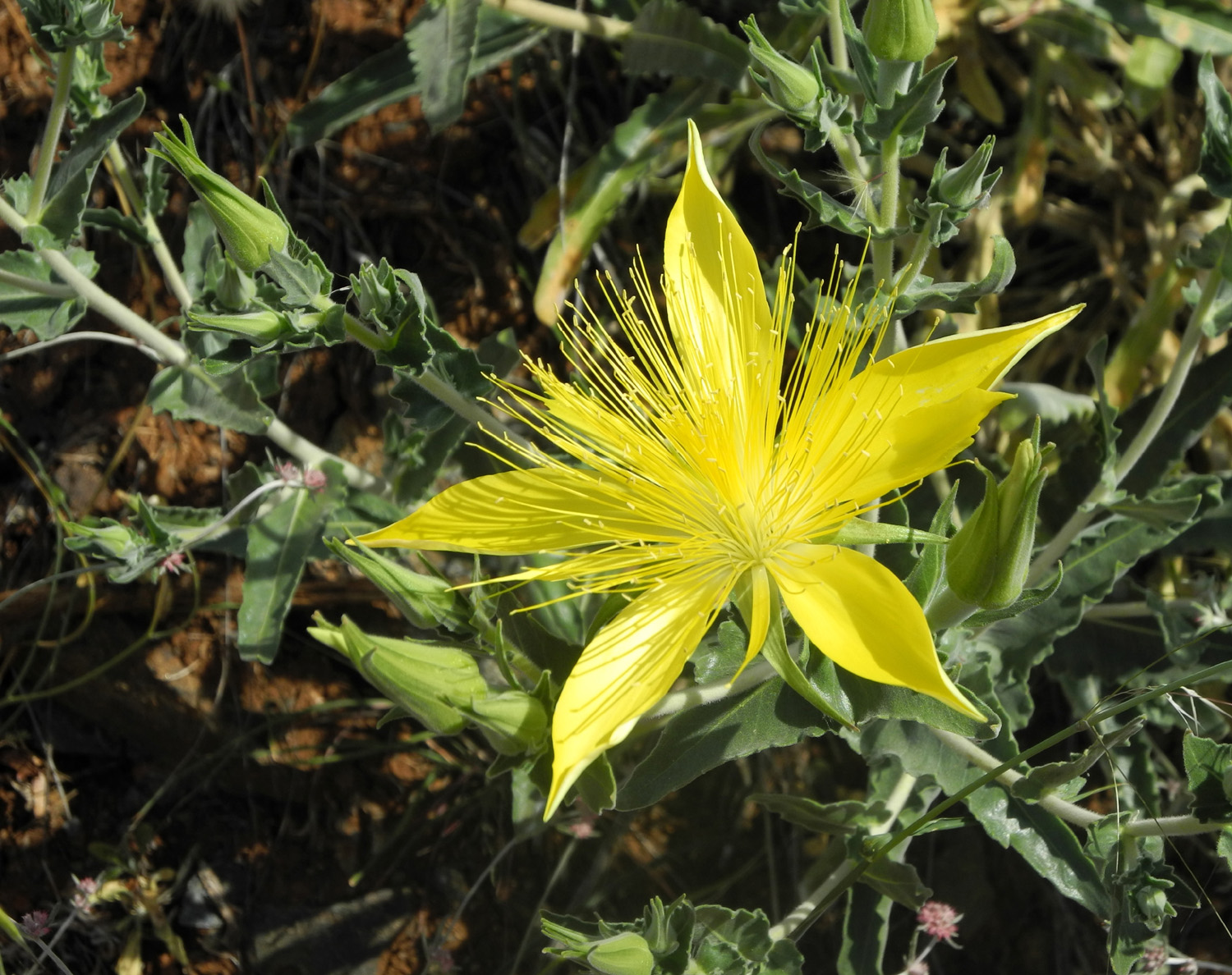
As expected, there were many species of wildflowers in evidence, including a few samples of early bloomers and plenty of late season blossoms. These included Mariposa lilies, fiesta flowers, an unknown tall white species, fiddlenecks, dove lupines, farewell-to-spring, clarkia, baby blue eyes, thistle, owl clover, popcorn flowers, vetch, filaree, harvest brodiaea, purple brodiaea going to seed; phecelia, and common madea. The flowers i decided were a variety of clarkia grew among the farewell-to-spring, and were almost the same pink color, but closer examination revealed the differences. |
|

|

|
| I believe this is a species of clarkia | Farwell-to-spring |

|

|
| This elegant flower needs to be identified | The last of the fiddlenecks |

|

|
| A fallen and twisted bull pine | A steep rough section of the trail |
|
My goal for hiking distance these days is between one and two miles, and I was happy to see that this one totaled 1.56 miles. Since this is not a properly engineered trail, there are several short but very steep sections, with loose dry soil, where I had to be extremely careful to avoid slipping or falling. In all honesty, I probably will not attempt this trail again, unless a method of reverse aging is discovered. Not holding my breath. Of course, on the return journey the downhill sections were up hill, which is easier walking, although harder on the lungs. And since the world is full of ups and downs, there was one rough section that went down on the return hike. Despite these challenges, I made it safely back to my car and home, looking forward to more hiking in the near future, probably at a somewhat higher and cooler elevation. --Dick Estel, May 2025 |
|
|
Finegold North This
is another of those unofficial trails upon which I have bestowed an
unofficial name. It starts at the Finegold Picnic Area, at the end of Sky Harbor Road. There is in fact an official trail that starts here, the San
Joaquin River Trail, that goes 14 miles to the San Joaquin Gorge
recreation area. I have walked a couple of miles on both ends of that
trail, but never the entire length.
Finegold North is partly a fishermen's trail and partly an old road that starts at the northwest corner of the turnaround loop at the end of the road, goes down close to the high water line on Lake Millerton, and around a point of land between the main lake and a little cove below the road. It's short, offers mostly easy walking with minimal up and down, and provides views of the lake and a few wildflowers. It's also only 22 miles from home, making it a good choice for a short, low-key outing throughout the winter and spring. |
|

|

|
| Farewell-to-spring along Sky Harbor Road | The little cove below the trail |
|
It
had warmed up to nearly 90 a few days earlier, and I thought my
foothill hiking was done for the year, but it cooled off again, so on
May 12 I drove out to Auberry Road, turned north on Millerton Road,
and got on the Sky Harbor Road. There were huge, thick patches of
farewell-to-spring in many places along the road, and the lake looked
like it was very close to full capacity. In fact, the California
Department of Water Resources web site showed it at 88%, up from
83% on April 28. There was a very cool breeze blowing upstream across
the lake, but I was comfortable with two t-shirts, a short sleeve and
long sleeve. Because hiking is warmer than sitting in my recliner, I
had considered wearing shorts, but when I saw how overgrown the trail
was, I was happy that I stuck with jeans. |
|

|

|
| These tall yellow flowering plants are thick in some places | Would it surprise you that I brought home a ton of stickers? |
|
With
more than a month of spring remaining, I hoped I would find at least a
few wildflowers still going strong, and I was not disappointed. After
the farewell-to-spring, the most common flower was Athurial’s spear.
This is a variety of brodiaea, sometimes confused with another variety
that I simply refer to as purple brodiaea. This purple one blooms early in
the spring, likes cool, shady, somewhat damp areas, and is a much
lighter purple than its relative.
Athurial’s spear is a deep purple color, has narrow, pointed petals, and is perfectly happy to grow in fields of dry grass during the second half of spring. Also seen in abundance was locoweed, also called moonflower and datura,
a big-leaf plant that grows about three or four feet tall and produces
big, white lily-like blossoms, around four inches in diameter. I have
seen these in the upper foothills, at low elevations like this, and in
Zion
National Park
in |
|

|

|
| Athurial's spear | Datura or locoweed |
|
There
were also a few lupines, poppies, fiddlenecks, filaree, and several
unidentified species. All in all, I was very pleased with this
late-season floral display. |
|
|
|
|

|

|
| The last of the lupines | A delightful specimin that needs a name |
|
My total hike was a little over a mile, and a little over two hours in duration. You can guess that I do not walk non-stop, but stop to rest, to look at flowers, and to take pictures. It was a perfect hike for me – close to home, not too hot, and I still had plenty of day left when I got home. --Dick Estel May 2025 |
|

|
Photos (Click to enlarge; pictures open in new window) |
||
|
San Joaquin Gorge & Yosemite Edison Point Make-up Finegold Fisherman Trail Finegold North |
||
|
San Joaquin Gorge
& Yosemite |
||
 |
 |
 |
| Farewell-to-Spring | A patch of blue dicks | El Capitan |
 |
 |
 |
| Top of Bridalveil Falls | Upper Yosemite Falls | Anne and Linda and Yosemite Falls |
 |
|
 |
| Another view of El Capitan | Sentinel Rock | Snowy cliffs on the south side of the valley |
 |
 |
 |
| A last view of two
major features above Yosemite Valley |
Snow on the hillside at Chinquapin | One of the original inhabitants of Yosemite |
| Edison Pont Make-up | ||
 |
|
 |
| Another view of the old shed | Farewell-to-Spring makes a pink carpet | Single blossom close-up |
 |
 |
 |
| Never before seen - white vetch | These flowers
appeared in great numbers along the Edison Point Trail |
The last of the lupines |
 |
 |
 |
| Some kind of clover | A patch of Mariposa lilies | Brodiaea were going to seed |
| Finegold Fisherman's Trail | ||
 |
 |
 |
| A patch of clarkia | I don't recall seeing this flower before | Harvest brodiaea blooms early and late |
 |
 |
 |
| A view across the lake from my trail | My walk ended at this drainage | The trail to the left becomes very steep |
|
 |
 |
| Little Table
Mountain, center right is a familiar landmark that can be seen from Highway 41 |
A field of common madea and a big oak tree | Here's a happy hiker |
| Finegold North | ||
 |
 |
 |
| Lake Millerton from Sky Harbor Road | Farewell-to-spring near the parking area | Lots of farewell-to-spring up close |
|
 |
 |
| Looking across the cove to the main lake | Datura by the lake | Datura platnt with big buds |
 |
 |
 |
| That slight
indentation across the picture is the trail |
Athurial's spear in its natural habiat | The very steep start/end of the trail |
| Related Links | ||
| Kings Canyon National Park | General Grant Tree | General Sherman Tree |
| Generals Highway | Kings Canyon Overlook | Sequoia National Park |
| Mt. Goddard | Duluth, MN | How to Make Maple Syrup |
| San Joaquin River Gorge | Yosemite National Park | Ahwahnee Hotel History |
| Yosemite Falls | Bridalveil Falls | Royal Arches |
| Mariposa Battalion | Book - Discovery of Yosemite | Ahwahnee Hotel |
| Yosemite Valley | More about the Valley | Wawona Tunnel |
| Yosemite Park Waterfalls | Edison Point Trail | Pine Flat Reservoir |
| Trimmer Springs Road | Mariposa Lilies | The OTHER Sky Harbor Hike |
| Millerton Lake | Datura | California Department of Water Resources |